SmartRain™

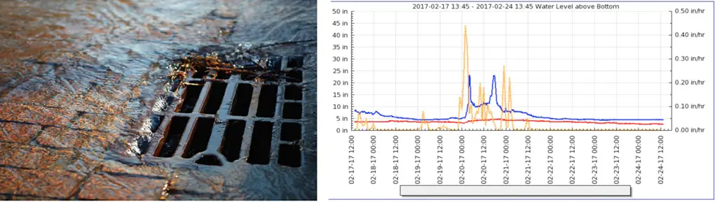
Rain Data Integration with Level and Flow Measurements
Rain data can be acquired from any desired location and presented in the user interface along with level or flow data in a single display (Figure 1 above). Data integration creates an easy method to view and understand the relationship of collection system level or flow changes as affected by rain.

Benefits:

Profiles the collection system during rain.
  • Maintenance-free with no set-up or maintenance required.
  • Multi-graph view of level or flow sites with rain sites.
  • Level and flow sites employ trend analysis (SmartTrend®)
  • Profiles the collection system during rain.

How SmartRain Works

SmartRain™ gauge location is determined by simply specifying latitude and longitude of the desired site. NOAA radar, combined and calibrated with ground-truth physical rain gauges, provides near-real time rainfall rates at the specified location. Locating multiple rain monitoring sites in a given sewer shed reveals “cause and effect” relationships in the basin. A “rain-field” using a grid of rain monitoring sites is easily deployed, enabling local variability of rain events to be captured. This can show timing and location of I&I at various SmartLevel™ monitoring points in your collection system.

Application

Inflow & Infiltration Application

When SmartRain™ is used in concert with level or flow data it quickly reveals sources of inflow and infiltration (I&I). These data sets are powerful tools for prioritizing capital improvement projects (CIP) to reduce I&I. Inflow and infiltration caused by rain, tide and rivers is a significant cost to the utility. Rain water that is processed as sewage is expensive.


Download Product Brochure

Need Reliable Liquid Measurement Products?

Call Us Today to Find the Right Flow Metering Solution for Your Needs!
Call Us Today

Trusted Since 1982 | Certified Expertise | End-to-End Solutions